INRIX 2024 Global Traffic Scorecard

The 2024 Global Traffic Scorecard provides three years of transportation data for a more granular and holistic analysis of mobility within the world's most-congested areas. It provides travel delay comparisons, costs of congestion to drivers and regions, and commuting trends based on the unique travel patterns within each metro area.

The Scorecard utilizes up to date, observed commute trips to truly analyze and compare how travel behavior differs in more than 900 cities across the globe.

Download the
Full Report
Jump to
City Rankings
7
37
900+

Ten Highest Traffic Delay Times By City

  • City 1
  • City 2
  • City 3
  • City 4
  • City 5
  • City 6
  • City 7
  • City 8
  • City 9
  • City 10

US Cities Congestion

View cities by:

Cost
$200
$400
$600
$800
$1,000
United
States
'23
$nnn
'24
$nnn
United
Kingdom
'23
$nnn
'24
$nnn

Germany
'23
$nnn
'24
$nnn

The Economic Cost
of Congestion

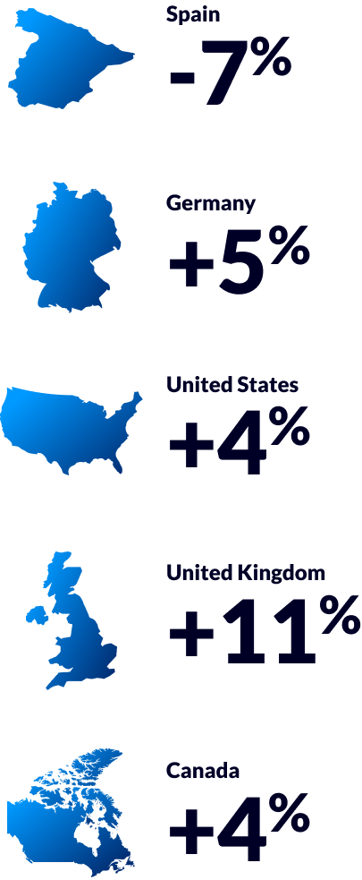
Traffic congestion occurs when demand for roadway travel exceeds the supply of roadways. As vehicular traffic builds, drivers, freight movers and bus riders lose time and spend fuel unproductively. That “lost time” has a value that we analyze in the 2024 Global Traffic Scorecard.

In addition to lost time, negative externalities like freight delay, inflationary pressure and environmental impact are generally exacerbated due to traffic congestion. While not measured in this report, these externalities decrease our quality of life.

Another large cost of travel is fuel. Throughout 2024, global oil prices resulted in a small decrease in fuel costs to motorists.

Downtown Trips

Throughout the pandemic, metro areas around the world experienced significant drops in trips to and from city centers as workers shifted to telecommuting and hybrid schedules. In addition, other businesses, dependent on office workers heading into downtown, often adjusted schedules or reduced services due to fewer in-person customers. Between 2021 and 2024, however, most downtowns saw increases in both vehicle volumes and travel times, though many downtowns still sit below pre-COVID norms.

2024 Trip Change & Peak Travel Time Change

-30%
-20%
-10%
Percent Change
10%
20%
30%
City Name
75% / 65%
City Name
75% / 65%
City Name
75% / 65%
City Name
75% / 65%
City Name
75% / 65%
City Name
75% / 65%
City Name
75% / 65%
City Name
75% / 65%
City Name
75% / 65%
City Name
75% / 65%
City Name
75% / 65%
City Name
75% / 65%
City Name
75% / 65%
City Name
75% / 65%
City Name
75% / 65%
City Name
75% / 65%
City Name
75% / 65%
City Name
75% / 65%
City Name
75% / 65%
City Name
75% / 65%

Shared Mobility Usage in 5 Select U.S. Cities

The Federal Transit Administration defines shared mobility as "transportation services that are shared among users, including public transit; taxis and limos; bikesharing; carsharing (round-trip, one-way, and personal vehicle sharing); ridesharing (carpooling, vanpooling); ridesourcing; scooter sharing; shuttle services; neighborhood jitneys; and commercial delivery vehicles providing flexible goods movement."

Over the last decade these transport modes have gained popularity in cities across the world. While these modes often replace car trips and provide first- and last-mile access, they also require cities to manage the curb and roadway differently, oversee their distribution and ensure compliance to deploy.

With the acquisition of Ride Report, INRIX bolstered its coverage of shared mobility data. The latest trends reveal micromobility use across 10 cities analyzed increased 17% year over year, indicating more people are returning to offices and are utilizing alternate and shared modes. A preview of five U.S. cities is below. Visit ridereport.org to view, analyze, and compare micromobility across all cities.

City Ranking List
Download the report
Want to learn more about traffic trends worldwide?
Download the report to learn more.
Download the Report

To download the INRIX 2024 Traffic Scorecard Report, please complete the following form.