


Urban transportation is undergoing a transformation—and the curb is at the center of it.
In cities, curb space is more than just a place to park; it’s a dynamic zone where delivery vans, rideshares, scooters, buses, and personal cars all compete for access. Managing that complexity is no small task. Until now, curb management has relied heavily on field surveys, static maps, or expensive sensors. But with INRIX Curb Analytics, cities can finally monitor, plan, and optimize every curb segment—in real time, with no hardware required.
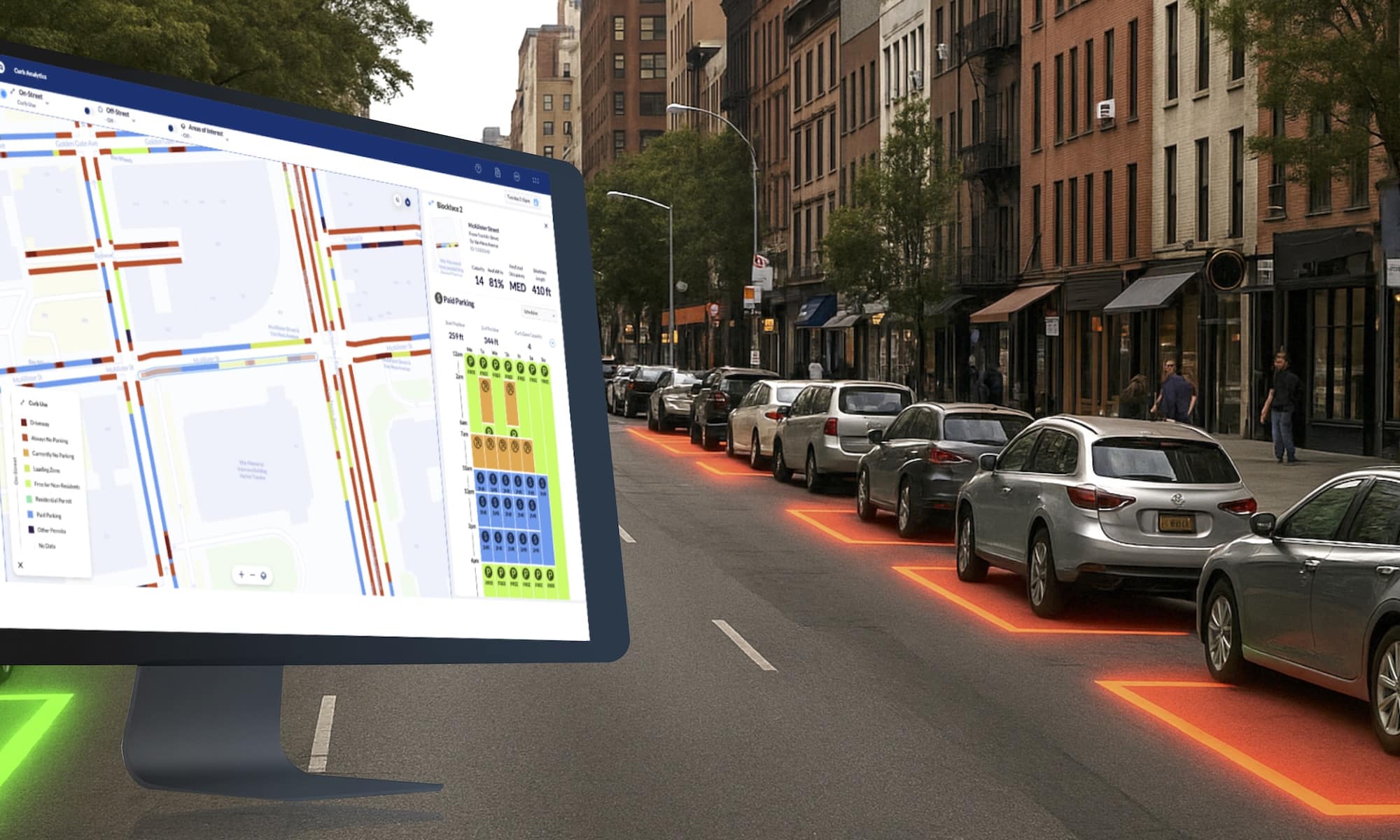
What is Curb Analytics?
Traditional parking studies quickly become outdated, and installing and maintaining sensors can be costly. Meanwhile, curb demand has shifted dramatically—especially after COVID-19. INRIX makes it easy for cities to stay ahead of these changes with Curb Analytics, a cloud-based solution that gives transportation teams a full picture of on- and off-street curb space, including availability, pricing, policies, and predicted demand—updated daily.
With it, cities can:
- Digitize curb maps instantly—including signs, bus stops, driveways, EV zones, and loading zones
- Predict occupancy in 15-minute intervals—to reduce circling, improve turnover, and ease congestion
- Track demand and reallocate space dynamically—from paid parking to micromobility, EVs, or delivery
It’s a non-sensor, turnkey solution powered by trillions of connected vehicle data points and 3+ million field-verified curb observations.
Cities can also track:
- On-street capacity: Both marked and implied/unmarked spaces, complete with curb length and details at a block or curb‑zone level.
- Off-street inventory: More than 200,000 parking facilities globally covered—including lots, garages, and entry points.
- Parking availability & occupancy: Live and historical trends reveal which lots are frequently full or open.
- Parking policies cataloged: Block-by-block zoning rules, paid hours, limits, EV stations, loading zones, etc.
- Curb use distribution: Classification of curb spaces into usage types like driveways, commercial loading, EV charging, paid parking, and more.
Real-World Use Cases
Curb Analytics supports a wide range of practical applications for city planners and mobility teams. For curbside project planning, it helps prioritize where to install new bike lanes, loading zones, or accessible parking based on real, location-specific data. When it comes to policy development, cities can use objective demand and occupancy insights to set smarter parking time limits, implement dynamic pricing, or designate EV zones more effectively. The platform also plays a key role in reducing traffic and emissions by minimizing circling behavior and improving curb turnover. And by providing accurate curb capacity data, it ensures cities can better support local businesses with easier, more predictable access for customers and employees alike.
Why It Matters Now
As cities evolve to meet the demands of modern mobility, the need for smarter, data-driven curb management has never been greater. Traditional parking studies and sensor-based solutions are often outdated before decisions can be made—but Curb Analytics changes that. With citywide, real-time visibility and predictive insights that update daily, INRIX empowers transportation leaders to make faster, more informed choices.
By combining high-fidelity curb digitization with advanced modeling, cities can now allocate space more effectively, anticipate demand, enhance equity, and reduce traffic congestion—all without installing a single sensor. INRIX provides the intelligence to manage the curb with confidence.
To learn more, watch the webinar: Solving the Parking Puzzle or visit inrix.com/products/curb-analytics/.