


You know the pain, you have an urgent appointment in a new area, and you just don’t know where to park.
INRIX have been major players in the parking prediction game for a while, having supplied various major car-brands with parking-availability predictions in city-centers successfully for years. So, we sympathize with you, as busy parents, commuters and people who need eye appointments, we feel the same pain.
Now in the post-pandemic though, with remote work happening in out-of-town offices, people are more distributed than ever. The demographics of those who drive are changing too, as is where we go. With the rise of the delivery economy, pop-up shops, trending coffee-shops, and dog-walking-influencers, it feels like the established rules no longer apply.
So how do you keep track of busy areas, and what does this mean for your ability to park there? This question is at the forefront of the minds of busy parents, the city councilors who manage the parking landscape, and us here at INRIX.
We have long tracked the busy areas across the country using a product we call Trips (the privacy-assured aggregated endpoints of tracked vehicles). This information can be useful in all kinds of ways, identifying busy areas, the impacts of cross-border tariffs on trade, and even predicting the financial performance of public companies.
By using this data to understand how busy an area is we can adapt the predictions of occupancy to the changing tastes of the people who live in those areas, picking up the fashions and fads with almost no lag. The best part is that we are not restricted to just the city-centers anymore, this Trips data covers the suburbs, the out-of-town shopping malls, country parks, hiking trails, the lot.
For the first time anywhere, we’re using real movement data to generate near real-time predictions of parking availability across a far wider area than any on-street parking service has been able to offer. By combining these signals with open-source maps and census data, we’ve built a model that delivers strikingly accurate forecasts of parking demand. This marks a major step forward: a system that reflects how people actually move and park today, wherever they go.
How It Works
- Building Our Baseline
We start with real-world observations: periodic manual surveys of curbside occupancy, plus cleaned and calibrated parking‐citation data. This gives us the “ground truth” for how full streets really get, across different neighbourhoods and times of day.
- Reading Live Demand Signals
We tap into our anonymised “Trips” feed—aggregated vehicle movement traces that update every few minutes. When more cars head toward a new café or event venue, we see that surge instantly.
- Mapping Tiles to Curbside
Rather than model each street individually, we split the entire area—city centres, suburbs, parks—into small, uniform tiles. Each tile inherits curbside characteristics (number of bays, nearby destinations) plus local population or employment density. It’s a consistent framework whether you’re downtown or in a country park.
- Blending Data with Machine Learning
At the heart of our system is a gradient-boosted decision-tree ensemble model. It’s trained to learn how live Trips signals, static map/census features, and observed occupancy levels interact. The output is an hourly regression forecast: the proportion of free spaces you can expect in each tile.
- Delivering Near-Real-Time Forecasts
Every 15 minutes, fresh movement data arrives. We rerun the ensemble model across all tiles, then interpolate between hourly estimates to create finer-grain (e.g., half-hour) predictions.
By combining hands-on occupancy checks, live vehicle flows, smart geospatial tiling and a gradient-boosted decision-tree ensemble, we’re the first to offer wide-area, near-real-time on-street parking forecasts—wherever you park.
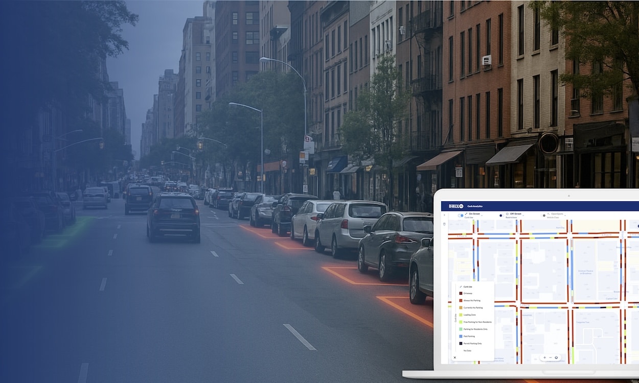
We just launched this On-Street Occupancy Prediction feature in INRIX Curb Analytics that gives curb management staff insight into how full each curb segment is—hour by hour, day by day—across an entire city. To learn more, watch this free on-demand webinar to learn how cities use parking data and occupancy insights to improve curb management, boost enforcement, and ensure a parking spot is available on every block.