


On January 7, 2025, a California wildfire threatened the Pacific Palisades, a Westside residential neighborhood in the Los Angeles area, surrounded by the Santa Monica Mountains.
The area is one of the most fire-prone regions in California, due to winds, the types of vegetation in the area, and a lack of precipitation and prominence of drought conditions. Further, dense housing and physical environmental barriers create difficult conditions for evacuations. During the Palisades Fire extreme drought conditions combined with high winds caused rapid fire to spread, where more than one thousand structures were destroyed, 12 lives were lost, and economic losses reached an estimated hundreds of billions of dollars.
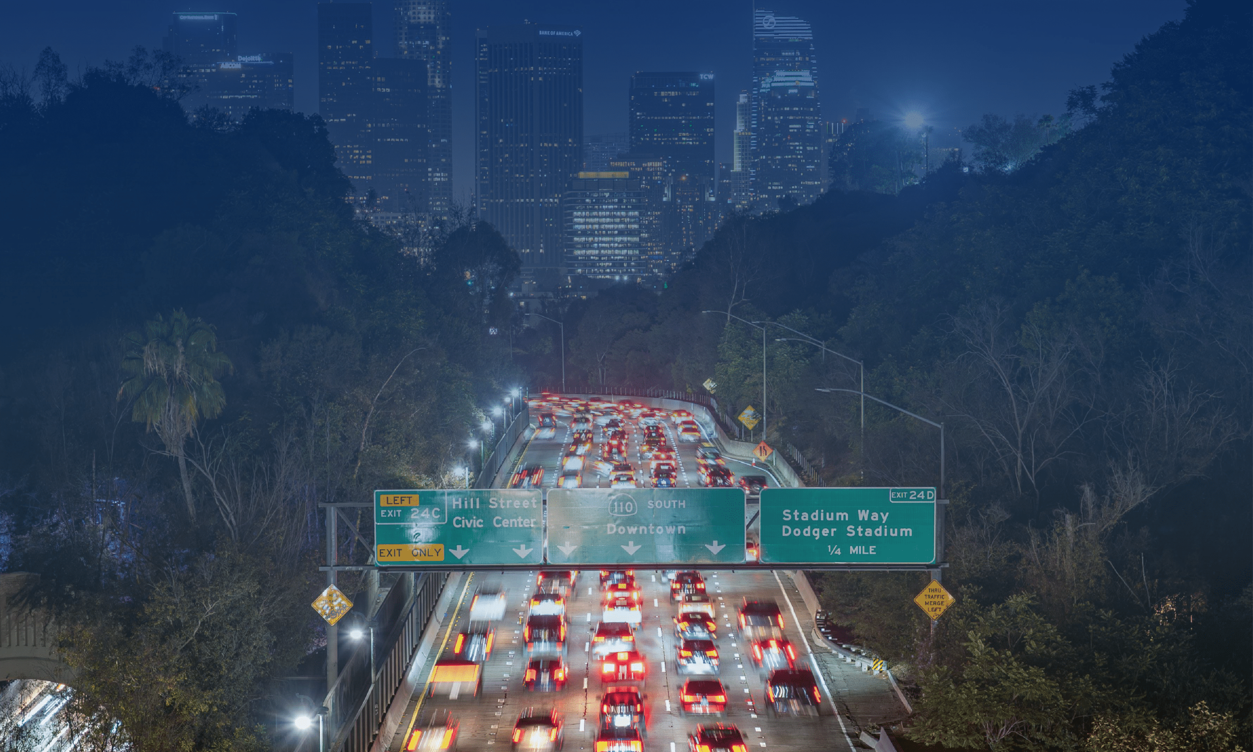
The rapid spread of the fire overwhelmed the road network as residents attempted to evacuate simultaneously. Traffic volumes quickly exceeded roadway capacity, forcing some evacuees to abandon their vehicles and flee on foot. Severe congestion occurred at multiple key bottleneck locations, limiting both evacuation and emergency response efforts.
The tragic loss of life and property led University of Maryland CATT Lab researchers to analyze evacuation dynamics in detail, providing public agencies, decision-makers and the public with granular roadway performance insights to identify ways future fire events and evacuations can better move people to safety.
Methodology & Webinar
The research group utilized INRIX data, along with various analytics tools, to match evacuation travel patterns with the physical infrastructure. Understanding the demand for travel allows transportation engineers and safety experts the ability to reduce friction along the roadway during an evacuation.
You can find the presentation about their findings below:

RITIS User Group YouTube Video
Evacuation Routes, Flows, and Topography
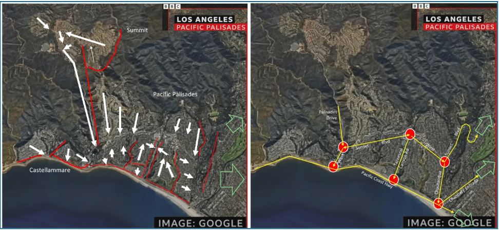
The research team noted various natural barriers which challenged evacuation efforts (red), along with the evacuation flows from neighborhoods (white). Those seeking safety would head East to avoid the fast-spreading flames from the north/northwest. Six traffic bottleneck locations (red circles) stood out for further study along the evacuation routes (yellow).
Day of Analysis
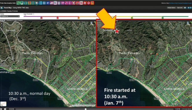
Their analysis begins around 10:30 am, when the fire was first reported on the 1100 block of North Piedra Morada Drive. Compared to the baseline day of December 3, 2024 (the “normal day”) morning traffic patterns were similar to the day of the fire on January 7th. However, within 30 minutes, UMD researchers noted traffic began to degrade heading Eastbound on parts of Sunset Boulevard as people fled to safety away from the fire.
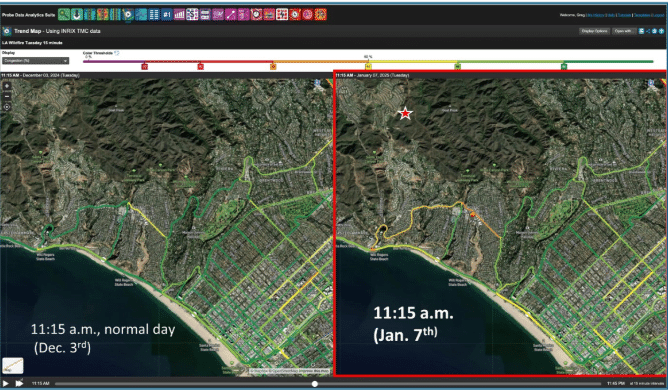
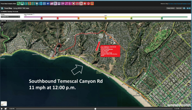
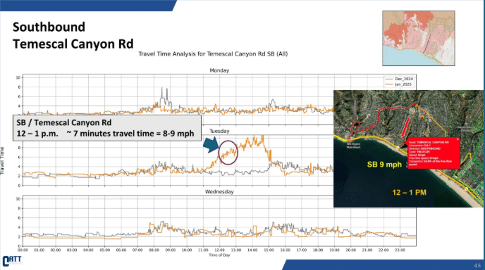
Within 15 minutes (11:15am), the entire Eastbound corridor to Temescal Canyon Road had slowed significantly, reaching full degradation in another 30 minutes (11:45am), when speeds fell to just 8 mph. From that intersection, drivers faced the choice of heading Southbound on Temescal Canyon Road or continuing on Sunset Boulevard, and by noon, speeds had fallen to just 11 mph southbound on Temescal Canyon Road.
By 1:00 pm the Pacific Coast Highway slowed to 12 mph, and the W. Channel / Entrada Corridor to Santa Monica crawled at 7 mph. By 3:15 pm, the West section of Sunset Boulevard stopped reporting data, as speeds were too slow.
Soon after the fire engulfed both sides of W Sunset Boulevard as it headed downhill – and police ordered evacuation on-foot.
Data & Analysis
Travel times jumped significantly due to the evacuations:
- Sunset Boulevard EB (E. of Temescal): More than doubled to 40-50 minutes between 1:00 pm and 3:00 pm.
- SB Temescal Canyon Road: Travel times more than tripled by 1:00 pm
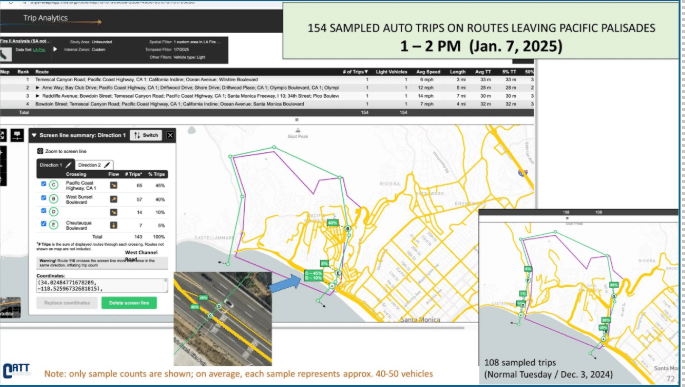
Trip origin and destination analysis revealed that between 10:00-11:00 am, 83% of trips were heading Eastbound to safety, that number jumped to 100% by 1:00 pm.
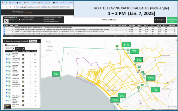
During the 12:00-1:00 hour, researchers stated that the number of vehicles leaving the Palisades surged 59% over normal. In addition, 43% of those vehicles were attempting to leave via Sunset Boulevard, versus 26% on a typical day. As a result, it’s estimated that traffic volumes surged on Sunset Boulevard by approximately 159% over normal, overwhelming the roadway.
Community Feedback
Public officials have produced after – action reports in an effort to avoid a similar situation in the future. Some of the key feedback points received from the public:
- “No clearly recognized, centralized source of accurate information that community members knew about or were able to use for guidance, particularly regarding available resources and the latest evacuation routes. Page 50
- “The extreme and rapidly moving fire conditions challenged the situational awareness of fire and law enforcement first responders…residents expressed frustration over wanting more frequent updates and their reliance on unofficial sources, such as social media and community groups.” Page 50
- “Evacuation decisions and messages could not keep pace with the fire. Once Unified Command communicated an evacuation decision, the fire had already impacted another zone.” Page 51
- “Some said that while evacuating, they encountered blocked roads and did not witness any emergency personnel helping to direct traffic…” Page 51
Improvements
The County and other government agencies have incorporated numerous changes to improve evacuation efforts to reduce the strain on the road network and speed up evacuations. Some changes include:
- Improved fire detection systems that to receive information quicker.
- Computer aided dispatch upgrades.
- Evacuation warnings will be send to zones adjacent to Evacuation Order zones. This process has been used with other fire evacuations and is now a standardized best practice. According to the report, this will “provide residents in potentially at-risk areas more time to plan for a possible evacuation,” thereby reducing the surge of traffic volumes on the roadway.
Los Angeles Mayor Karen Bass also said an evaluation will be completed to “include recommendations on “how to improve evacuation routes and procedures.”
Conclusion
The University of Maryland’s analysis shows how big data can play a critical role in understanding what happens when evacuations unfold in real time. By pinpointing the corridors and intersections that experienced the most severe congestion, researchers were able to clearly illustrate how quickly demand overwhelmed the transportation network during the Palisades Fire.
These insights give public officials a valuable opportunity to act before the next disaster. Operational changes, such as earlier and more targeted evacuation warnings, can help spread travel demand over time, while infrastructure improvements can reduce chokepoints along critical routes. Taken together, data-driven analysis offers a powerful tool for turning hard-learned lessons into safer, more effective evacuation strategies for the future.
Learn more by downloading the INRIX 2025 Global Traffic Scorecard.