


The transportation revolution is happening and it’s happening across every mode of movement. Whether it’s autonomous capabilities in the newest cars or tracking the precise location of your city bus that was expected to arrive two minutes ago or comparing multiple routes and mode choices before making a decision. The common theme is that we’re all using data to improve how we travel. The public and private sectors acknowledge it’s nearly impossible to build your way out of congestion. INRIX is focusing on making transportation safer and more efficient with the roads we already have – using big data.
When you’re told that everything is normal it isn’t very interesting, but navigational anomalies are highly interesting when it comes to the delay minutes associated with your commute, or the cause and effect of incidents on your route – this type of data helps you make navigational decisions tied to when to leave or what detour to choose. In addition, there are safety-related alerts that can bring awareness to human or machine actions that should be taken in advance of conditions ahead. This is where the Incident team at INRIX has focused much of our attention over the past few years so that we can discover the anomalies and send them to vehicles in near real time. We’ve put a lot of effort toward considering both humans and machines in how we send our incident data. As the navigational experience moves toward becoming a partnership between humans and machines, we need to consider features such as natural language text-to-speech for hands-free communications, dynamic location referencing and high resolution spatial referencing. We must also apply advanced merging and deduplication of incidents so that drivers are not continually alerted about the same event. We must calculate the rate of growth for the congestion queue so that we’re able to properly project when a driver notification must be sent to warn of an upcoming slowdown. We’ve partnered with auto OEMs to get real-time vehicle data for critical events such as air bag deployments, traction control and atmospheric data to be used by nearby drivers so they know what’s happening around them – one vehicle reports, many benefit. And because INRIX has rich GPS flow data we can apply algorithms that automatically detect when roads are closed or impassable based on comparisons to historical models for a specific road, time of day, and day of week. We do all of this with the spatial and temporal accuracy required to make precise and reasonable decisions relating to the intricacies of the road network.
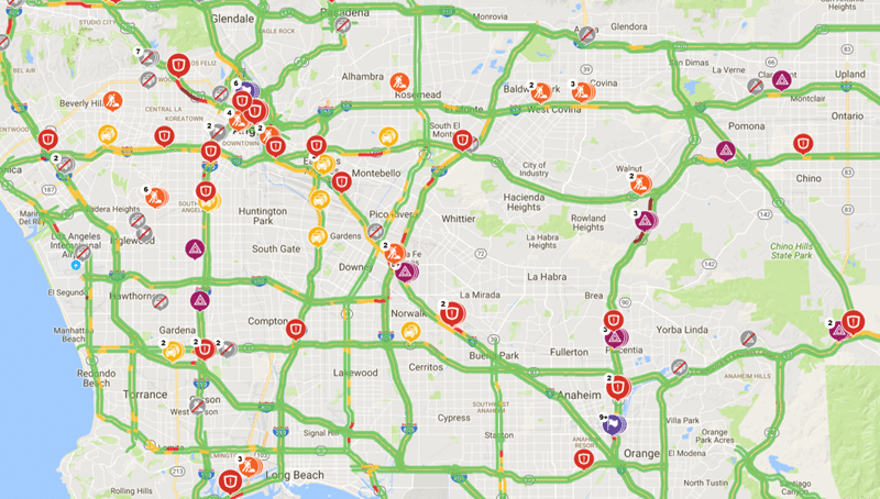
There are four primary categories of incidents that we send to our customers:
- Incidents: these are defined as closures, collisions, construction, and any event that has the potential to impede traffic or impact navigation. There is no bigger navigational sin than routing a driver through a closed road. INRIX leverages partnerships, crowd sourcing, algorithms and an awesome team to build the best-in-class detection and publication of incidents.
For example, knowing that semi-autonomous vehicles are already on the road (with highly autonomous vehicles coming soon) it is important that we are able to tell a vehicle that 2.2 kilometers ahead the four lane interstate will narrow to two lanes for precisely 3.1 kilometers before again widening to four active lanes; and during the two lane stretch all five exit ramps are closed; and there is also a stalled vehicle in the left hand shoulder 2.15 kilometers into the narrowed stretch of two lanes where recovery vehicles are operating.
- Algorithmically-generated flow-based incidents: based on the core INRIX GPS flow data, these are anomalous congestion events. They move, they grow, they change quickly and they impede traffic by way of travel time delays. This incident type is less about the why or what and more about travel time exceptions. Sometimes they’ll be tied to a collision or a lane closure, and sometimes they represent non-causal congestion. INRIX has billions of GPS readings from which to build historical models for each road in the network. From these we can determine the volume of traffic expected to traverse any stretch of road and then detect the absence of traffic, or rate of detour, for probes approaching the target segment signaling an inability to travel on specific sections of road. We can then determine what roads are closed with a high probability.
Similarly, INRIX monitors known closures for early re-openings when GPS probes are seen traversing closed stretches. We built these so that we could act faster by allowing the data to inform us of when a road become impassable or newly open. The auto close/open algorithms represent a relatively small percentage of total closures we know about, but the algorithm has proven to be a valuable detection tool intended to minimize the time it takes us to inform our customers of critical status changes to specific roads.
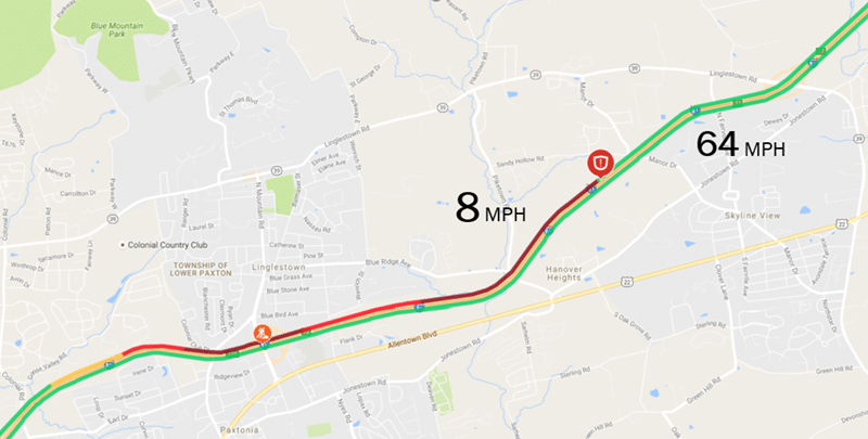
- Dangerous Slowdowns: The back of the queue can be a dangerous place, especially when the speed of traffic decreases from 70 KPH to 20 KPH within a short distance. This product identifies where traffic speeds drop rapidly and where a vehicle can be forewarned prior to encountering the queue. This is another example where INRIX has rolled up the underlying traffic data to publish severe braking Where sufficient real-time data exists, we provide an upstream location of the slowdown that will allow avoidance actions can be taken.
- Road Weather: INRIX produces warns that indicate the likelihood of weather-related safety events. Calculated from real-time vehicle data and atmospheric data, Road Weather provides nine types of weather conditions that produce hazardous driving alerts every 15 minutes. These can be pushed to vehicles for advance awareness of potentially hazardous road conditions.
The INRIX Incident team takes a lot of pride in knowing what is happening on the roads. For example, did you know that last year four separate roads were closed due to a swarm of insects? Did you know that the most common piece of furniture to cause an incident is a couch on the freeway, followed closely by refrigerators? We work hard to know all the details so that we can be as precise as possible in conveying what’s happening ahead of you so that you’re well informed and able to make the best decisions for you. Overall, we produce million incidents, including the ones that caused you agony on your way to work this week. Hopefully, the passion we put into providing great incidents allows you to spend an extra ten minutes having breakfast with your kids, make your deliveries on time, or inform your customers of the why, what, when and where of impacting events on the roads they care about.
Learn more about INRIX Traffic and Safety Solutions: https://www2.inrix.com/urban-mobility