


Cities face a challenge: how to keep people moving safely, efficiently, and sustainably. Congestion is climbing, public transit systems are under pressure, and the curb is packed.
It is a battle to find space between delivery vans, rideshares, scooters, and cyclists. Cities are no longer just managing traffic—they’re reimagining mobility. But to make bold, forward-thinking decisions, city planners and transportation officials need more than intuition—they need data.
The Leader in Transportation Intelligence
For over 20 years, INRIX has been at the forefront of transportation analytics, empowering thousands of agencies and cities worldwide with the tools they need to make streets safer, traffic flow smoother, and urban mobility more inclusive and efficient.
By transforming vast amounts of real-time and historical data into actionable insights, INRIX is helping cities move from reactive problem-solving to proactive, data-driven planning.
How INRIX Helps Cities Tackle Modern Mobility Challenges
Traditional transportation tools—like manual traffic counts and slow, limited studies—can no longer keep pace with today’s dynamic mobility needs. These systems often result in reactive management, leading to safety risks, inefficiencies, and missed opportunities. In a world demanding faster, smarter decisions, the need for real-time, systemwide transportation intelligence is rapidly growing.
INRIX is helping agencies move beyond traditional analytics to deliver actionable intelligence. With real-time, historical, and predictive insights, INRIX empowers transportation agencies to make proactive, informed decisions that improve safety, reduce congestion, and optimize infrastructure planning.
Here’s how INRIX’s solutions are making a real difference on city streets:
Reduce Congestion with Real-Time Traffic Insights
With INRIX Traffic cities can ease bottlenecks, shorten commutes, and enhance overall mobility without building new infrastructure.
INRIX Traffic also provides:
- More accurate ETAs
- Instantaneous traffic updates
- Traffic speeds of different lanes including interstates to intersections country roads to neighborhoods
Improve Safety by Identifying High-Risk Areas Early
Safety View combines crash, vulnerable road user, demographic and vehicle data to help you visualize, analyze, and prioritize safety improvement projects.
Safety View helps:
- Easily identify the most dangerous road segments to target
- Measure the success of Vision Zero projects in a few clicks
- Accelerate funding opportunities with the right reports & datasets
Manage New Mobility Options
Whether it’s bikes, scooters, rideshares, or autonomous vehicles, Road Rules helps cities understand how these modes impact the street and curb—ensuring everyone can coexist safely and efficiently.
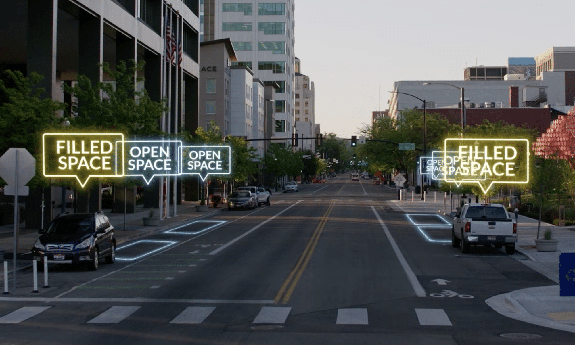
Improve Last-Mile Policy with Curb and Parking Analytics
INRIX Curb Analytics digitizes and visualizes the curbside to help cities maximize accessibility, availability, revenue, and safety for people driving, walking, and riding on scooters.
With Curb Analytics:
- Gain deep visibility into your curb space
- Enhance urban mobility using data-driven insights
- Plan for the future and make your city more livable
Optimize EV Charger Placement and Infrastructure Planning with Ground Truth Data
With the surge in electric vehicle adoption, cities need accurate data to plan EV charger placement and infrastructure. INRIX Trip Analytics provides “ground truth” insights to ensure chargers are built where they’re needed.
Trip Analytics provides:
- Accurate information on origin-destination data
- Enhanced transportation planning
- Emergency response planing
A Partner for a Smarter, Safer, Greener Future
Whether you’re battling congestion, improving safety, planning for EV growth, or rethinking the curb, INRIX is here to help you make smarter decisions. Learn more by visiting inrix.com/products/ or watch the video!